Tuesday, June 4, 2013

Attitude - Content , Structure , Function


What is an Attitude?


The word attitude crops up often in our everyday conversation.We speak of having attitude about something.In this usage,attitude usually implies feelings that are either positive or negative.We also speak of someone who has a "bad attitude".We may for example think that a colleague has an "attitude problem".In this usage,attitude implies some personality characteristic or behaviour pattern that offends us.Attitude is a mental and neural state of readiness,organized through experience,exerting a directive or dynamic influence on the individual's response to all objects and situations with which it is related.

Psychologists define attitudes as a learned tendency to evaluate things in a certain way. This can include evaluations of people, issues, objects or events. Such evaluations are often positive or negative, but they can also be uncertain at times. For example, you might have mixed feelings about a particular person or issue.

Attitude structure 

Researchers also suggest that there are several different components that make up attitudes

Affective component: this involves a person’s feelings / emotions about the attitude object(refers to the emotional reactions or feelings an individual has towards an object, person, group, event or issue.). For example: “I am scared of spiders”.

Behavioral (or conative) component: the way the attitude we have influences how we act or behave ( refers to the way in which an attitude is expressed through our actions.) .For example: “I will avoid spiders and scream if I see one”.

Cognitive component: this involves a person’s belief / knowledge about an attitude object(refers to the beliefs we have abou an object, person, group, event or issue.). For example: “I believe spiders are dangerous”.

This model is known as the ABC model of attitudes. The three components are usually linked. However, there is evidence that the cognitive and affective components of behavior do not always match with behavior. This is shown in a study by LaPiere (1934).

Attitudes can also be explicit and implicit. Explicit attitudes are those that we are consciously aware of and that clearly influence our behaviors and beliefs. Implicit attitudes are unconscious, but still have an effect on our beliefs and behaviors.

How are attitudes formed?

Attitudes form directly as a result of experience. They may emerge due to direct personal experience, or they may result from observation. Social roles and social norms can have a strong influence on attitudes. Social roles relate to how people are expected to behave in a particular role or context. Social norms involve society's rules for what behaviors are considered appropriate.Process of socialization influences the attitude formation.

Attitudes can be learned in a variety of ways. Consider how advertisers use classical conditioning to influence your attitude toward a particular product. In a television commercial, you see young, beautiful people having fun in on a tropical beach while enjoying a sport drink. This attractive and appealing imagery causes you to develop a positive association with this particular beverage.(Classical conditioning or Pavlovian conditioning is a reflexive or automatic type of learning in which a stimulus acquires the capacity to evoke a response that was originally evoked by another stimulus.)

Operant conditioning can also be used to influence how attitudes develop. Imagine a young man who has just started smoking. Whenever he lights up a cigarette, people complain, chastise him and ask him to leave their vicinity. This negative feedback from those around him eventually causes him to develop an unfavorable opinion of smoking and he decides to give up the habit.(Operant conditioning ,sometimes referred to as instrumental conditioning is a method of learning that occurs through rewards and punishments for behavior.It is the learning based on direct experience with the object. Through operant conditioning, an association is made between a behavior and a consequence for that behavior.)

Finally, people also learn attitudes by observing the people around them. When someone you admire greatly espouses a particular attitude, you are more likely to develop the same beliefs. For example, children spend a great deal of time observing the attitudes of their parents and usually begin to demonstrate similar outlooks.

Details :

Theories of attitude formation and change :

Functionalist theory:

Daniel Katz proposed a functionalist theory of attitudes. He takes the view that attitudes are determined by the functions they serve for us. People hold given attitudes because these attitudes help them achieve their basic goals. Katz distinguishes four types of psychological functions that attitudes meet.

A. Instrumental - we develop favorable attitudes towards things that aid or reward us. We want to maximize rewards and minimize penalties. Katz says we develop attitudes that help us meet this goal. We favor political parties that will advance our economic lot - if we are in business, we favor the party that will keep our taxes low, if unemployed we favor one that will increase social welfare benefits. We are more likely to change our attitudes if doing so allows us to fulfill our goals or avoid undesirable consequences.

B. Knowledge - attitudes provide meaningful, structured environment. In life we seek some degree of order, clarity, and stability in our personal frame of reference. Attitudes help supply us with standards of evaluation. Via such attitudes as stereotypes, we can bring order and clarity to the complexities of human life.

C. Value-expressive - Express basic values, reinforce self-image. EX: if you view yourself as a Catholic, you can reinforce that image by adopting Catholic beliefs and values. EX: We may have a self-image of ourselves as an enlightened conservative or a militant radical, and we therefore cultivate attitudes that we believe indicate such a core value.

D. Ego-defensive - Some attitudes serve to protect us from acknowledging basic truths about ourselves or the harsh realities of life. They serve as defense mechanisms. EX: Those with feelings of inferiority may develop attitude of superiority.

Katz's functionalist theory also offers an explanation as to why attitudes change. According to Katz, an attitude changes when it no longer serves its function and the individual feels blocked or frustrated. That is, according to Katz, attitude change is achieved not so much by changing a person's information or perception about an object, but rather by changing the person's underlying motivational and personality needs.

EX: As your social status increases, your attitudes toward your old car may change - you need something that better reflects your new status. (For that matter, your attitudes toward your old friends may change as well).


Learning theory 

There are several means by which we learn attitudes.

a. Classical conditioning- EX: A father angrily denounces the latest increase in income taxes. A mother happily announces the election of a candidate she worked for. These parents are expressing opinions, but they are also displaying nonverbal behavior that expresses their emotions. For a child watching the parents, the association between the topic and the nonverbal behavior will become obvious if repeated often enough. And the nonverbal behavior will trigger emotional responses in the child: the child feels upset and disturbed when listening to the father and happy when listening to the mother.

This is an example of classical conditioning: when two stimuli are repeatedly associated, the child learns to respond to them with a similar emotional reaction. In this case, the stimuli are the attitude topic and the parental emotion. Through repeated association, a formerly neutral stimulus (the attitude topic - taxes or politicians) begins to elicit an emotional reaction (the response) that was previously solicited only by another stimulus (the parental emotion). Whenever tax increases are mentioned, the child feels an unpleasant emotion; when the elected official is mentioned, the child feels a pleasant emotion.

EX: Pavlov's dogs. Bell was rung when dogs received food. Food made dogs salivate. Then whenever a bell was rung, dogs salivated even when food was not present.

EX: When you were a child, parents may have cheered for N.D. football. You may not have even known what N.D. football was, but you liked your parents happy attitude. Now N.D. football evokes that same response in you.

EX: Men with bow ties. Meet a bad man who wears bow ties, and you may come to hate all bow ties.

COMMENT: This explains why behaviors can persist even after reinforcement is withdrawn. Also helps explain self-reinforcement.

b. Instrumental, or operant, conditioning-Behaviors or attitudes that are followed by positive consequences are reinforced and are more likely to be repeated than are behaviors and attitudes that are followed by negative consequences.

c. Observational learning-Children watch the behavior of people around them and imitate what they see. EX: If a young girl hears her mother denounce all elected officials as crooks, she may repeat that opinion in class the next day. Whether she continues to repeat that opinion depends on the responses of her classmates, teacher, and parents. That is, observations determine the responses we learn, but reinforcement determines the responses we express.


Cognitive-Dissonance theory

 Cognition means individuals perception of own attitudes, beliefs, behaviors. Cognitive dissonance means feelings of tension that arise when one is simultaneously aware of two inconsistent cognitions. For example, when we act contrary to our attitudes; or, when we make a decision favoring one alternative despite reasons favoring another.


Dissonance theory says relationships among two cognitions can be either consonant, dissonant, irrelevant.Cognitive dissonance is a noxious state. It produces unpleasant physical arousal.Individual will attempt to reduce or eliminate dissonance - and will try to avoid things that increase dissonance.People can change their attitudes when they have conflicting beliefs about a topic. In order to reduce the tension created by these incompatible beliefs, people often shift their attitudes.


Theory of persuasion

This theory suggests that people can alter their attitudes in two ways. First, they can be motivated to listen and think about the message, thus leading to an attitude shift. Or, they might be influenced by characteristics of the speaker, leading to a temporary or surface shift in attitude. Messages that are thought-provoking and that appeal to logic are more likely to lead to permanent changes in attitudes.


Other theories include balance theory, originally proposed by Heider (1958), and the self-perception theory, originally proposed by Daryl Bem.


Functions of Attitude :


Attitudes can serve functions for the individual. Daniel Katz (1960) outlines four functional areas:

• Knowledge: Attitudes provide meaning (knowledge) for life. The knowledge function refers to our need for a world which is consistent and relatively stable. This allows us to predict what is likely to happen, and so gives us a sense of control. Attitudes can help us organize and structure our experience. Knowing a person’s attitude helps us predict their behavior. For example, knowing that a person is religious we can predict they will go to Church.

• Self / Ego-expressive: The attitudes we express (1) help communicate who we are and (2) may make us feel good because we have asserted our identity. Self-expression of attitudes can be non-verbal too: think bumper sticker, cap, or T-shirt slogan. Therefore, our attitudes are part of our identify, and help us to be aware through expression of our feelings, beliefs and values.

• Adaptive: If a person holds and/or expresses socially acceptable attitudes, other people will reward them with approval and social acceptance. For example, when people flatter their bosses or instructors (and believe it) or keep silent if they think an attitude is unpopular. Again, expression can be nonverbal [think politician kissing baby]. Attitudes then, are to do with being apart of a social group and the adaptive functions helps us fit in with a social group. People seek out others who share their attitudes, and develop similar attitudes to those they like.

• The ego-defensive function : refers to holding attitudes that protect our self-esteem or that justify actions that make us feel guilty. For example, one way children might defend themselves against the feelings of humiliation they have experienced in P.E. lessons is to adopt a strongly negative attitude to all sport. People whose pride has suffered following a defeat in sport might similarly adopt a defensive attitude: “I’m not bothered, I’m sick of rugby anyway…”. This function has psychiatric overtones. Positive attitudes towards ourselves, for example, have a protective function (i.e. an ego-defensive role) in helping us reserve our self-image.

The basic idea behind the functional approach is that attitudes help a person to mediate between their own inner needs (expression, defense) and the outside world (adaptive and knowledge).


More Info :Click Here


Sunday, June 2, 2013

Indo-Japan relations


Throughout history, India–Japan relations have always been strong. For centuries, India and Japan have engaged in cultural exchanges, primarily as a result of Buddhism which spread indirectly from India to China and then to Japan. During the Second World War, Subhas Chandra Bose's Indian National Army and the Japanese Imperial Army fought together in battles against the British forces.India is the largest recipient of Japanese official development assistance (ODA).

Political relations between the two nations have remained warm since India's independence. Japanese companies, such as Sony, Toyota, and Honda, have manufacturing facilities in India, and with the growth of the Indian economy, India is a big market for Japanese firms. Japanese firms were, in fact, some of the first firms to invest in India. The most prominent Japanese company to have an investment in India is automobiles giant Suzuki, which is in partnership with Indian automobiles company Maruti Suzuki, the largest car manufacturer in the Indian market and a subsidiary of the Japanese company.

In December 2006, Indian Prime Minister Manmohan Singh's visit to Japan culminated in the signing of the "Joint Statement Towards Japan-India Strategic and Global Partnership". Japan has funded many infrastructure projects in India, most notably the Delhi Metro system. Also, in the year 2007, the Japanese Self-Defence Forces took part in a naval exercise in the Indian Ocean, known as Malabar 2007, which also involved the naval forces of India, Australia, Singapore and the United States. The year 2007 was declared "India-Japan Friendship Year."

According to a 2013 BBC World Service Poll, 42% of Japanese people view India positively, with only 4% expressing a negative view.


Prime Minister visit to Japan - 2013

Highlights 

The main message covered by PM during his range of activities in Tokyo is that India looks forward to expanding the strategic and global partnership with Japan.This covers political exchanges, economic interactions and strategic affairs.

 On Tuesday, March 26, Minister for Foreign Affairs Mr. Fumio Kishida held the Seventh Japan-India Foreign Ministers’ Strategic Dialogue with  Mr. Salman Khurshid, External Affairs Minister of India, during the latter’s visit to Japan.The two Ministers affirmed that Japan and India will continue to move forward with talks on this issue of Civil Nuclear Energy Cooperation.Minister Kishida expressed his intention to hold the second round of the Japan-India Cyber Dialogue and the Japan-India Maritime Affairs Dialogue within this year.

India and Japan have agreed to institutionalize bilateral naval exercises, to conduct them regularly and with increased frequency.

The Japanese Government has offered to sell the US-2 amphibious aircraft to India.Japan’s unwavering support for India’s development process, and the DMIC, the Western Dedicated Freight Corridor, and now what is emerging as a new area of cooperation which is the Chennai-Bengaluru Industrial Corridor are all symbols of this commitment of Japan.

Co-finance a joint feasibility study on the possible introduction of high-speed railways or Shinkansen on the Mumbai-Ahmedabad route in India.

India and Japan are also cooperating in the field of rare earths. A government-to-government memorandum was signed by the Ambassador last November and it is already in place. Companies from India and Japan – the Indian Rare Earths Limited and Toyota Tsusho – are negotiating the sale of rare earth oxide.

The Genesis programme under which Prime Minister Abe said he would like to have more than a thousand young Indian people come and visit Japan

Japan’s contribution to the Nalanda University, which is coming up, through the Faculty of Peace Studies .


Prime Minister Singh appreciated the pledge by Prime Minister Abe for the Campus Development Project of Indian Institute of Technology, Hyderabad (Phase 2) for 17.7 billion yen and the “Tamil Nadu Investment Promotion Programme” for 13 billion yen.

More Info : Joint Statement on Prime Minister's visit to Japan


Tuesday, May 28, 2013

Indian Wildlife (Documentaries)


Home to over a billion people, India is best known as a diverse mass of noise, crowds, colour and religious devotion. She also has a wild side, populated by giants, predators and exotic creatures. Wild India gives you a fascinating insight into this world-within-a-world, as each show explores the country's extraordinary landscapes and their inhabitants.

Elephant Kingdom


To the south of the Himalayas lie wild plains, divided by the Brahmaputra river and home to the magnificent Indian Elephant. In this episode you'll also see red silk cotton trees and rare and beautiful creatures, from the smooth-coated otter to the endangered one-horned rhinoceros, all living together in a perfectly balanced ecosystem.

Tiger Jungles


The setting for Rudyard Kipling's 'The Jungle Book', these forests are filled with real-life stories - from langur monkeys intoxicated on fermented Mahua fruit to the Bengal tiger, a beautiful killer combining stealth and power to kill with a single bite.


Desert Lions


Marusthali is India's region of death - a dune-covered desert where existence demands resilience and adaptation. Yet even in this unrelenting heat, life thrives, from the Asiatic lion to the Demoiselle crane. Each creature is living proof that wildlife can survive in even the most hostile of environments.


Friday, April 26, 2013

Union Budget 2013-14 : Highlights

Union Finance Minister P. Chidambaram presented his much anticipated budget proposals for the year 2013-14, bringing a partial relief for the lower income groups as no changes were made in Income Tax rates or slabs. His budget could be lauded for certain proposals like set up of a first women’s bank, Rs 1 lakh deduction for home loans and more focus on health, education, HRD and rural development.

However, most of the commodities and articles get costlier in the budget proposals. Smartphones, Cigarettes, watching movies and eating out in AC restaurants will be more expensive in the coming days. Even though, Chidambaram called “higher growth leading to inclusive, sustainable development” as his government’s mantra, he failed to satisfy middle class society presenting the budget today. The government expected to get Rs 13,300 crore from change in direct tax and indirect tax proposal to yield Rs 4,700 crore.

The Fiscal deficit was marginally lower(5.2) than Economic Survey deficit figure of 5.3%, but it is enough to stop market decline for time being, as the minister expected.

Chidambaram looked more energetic while announcing the proposals for the fiscal 2013-14, which is the last budget before the general elections. He looked forward to change the fortunes of India, Asia’s third largest economy, after years of policy paralysis and global economic turmoil. He admitted that Indian export has been hit and global economy has slowed in the current fiscal. He said that Indian economy has slowed after 2010.

However, he defended the government for Food inflation and price hike that put pressure on common men in India. The slow economy has affected all the nations, only China and Indonesia are growing faster than India. Hence, there was no reason for gloom or pessimism. He stressed on the encouragement of foreign investment, which should be the economic objective for a developing nation. He claimed that the government is committed to work towards development of the nation. He talked about the proposed National Food Security Bill, which is the promise of the UPA government.

Proposals:

1. Rs 1630825 crore total expenditure, Rs 555322 crore plan expenditure, non-plan Rs 1199074 crore
2. Rs 41000 crore for Scheduled Caste and Rs 28500 crore for tribal welfare.
3. Rs 3,511 crore allocated to Minority Affairs Ministry which is 60% of the revised estimates.
4. Health and education for all remain priorities. Over Rs 33000 crore to health
5. Rs 4727 crore for medical research. Rs 1069 cr for the development in the ayurveda, allopathy and Homeopathy medical science
6. Rs 21,000 crore allocation for health sector
7. Allocation of Rs 65,000 crore for education sector
8. Rs 65000 crore to ministry of education, Rs 27257 crore to Sarva Shiksha Avijan
9. Rs 3983 for Rashtriya Madhyamik siksha abhiyan
10. Rs 13215 crore for mid-day meal scheme
11. Rs 17700 crore for ministry of children
12. Rs 110 crore to dept of disability affairs under specific scheme
13. Rs 1400 crore for water purification
14. Rs 65,867 cr allocated to ministry of human resources, 17% increase in budgetary support.
15. Rs 33000 crore for MNREGA
16. Rs 3400 crore for agricultural research
17. Rs 700000 crore for agricultural credit schemes.
18. Rs 1000 crore to support increased rice production in Eastern Indian states.
19. Rs 9954 crore and Rs 2250 crore for crop diversification under different schemes.
20. Rs 500 crore for crop diversification
21. Rs 15269 crore for water and sanitation
22. Rs 14,800 crore under JNNURM. Positive for Ashok Leyland, Tata Motors
23. National Livestock Mission launched with Rs 307 crore
24. Rs 10000 crore set apart for National Food Security Bill (if passed)
25. Rs 1650 crore for six more AIIMS-like medical institutes, which will start functioning this year.
26. All flagship programmes fully funded
27. Indian Institute of BioTechnology to be set up at Ranchi
28. Flagship Education scheme, Sarva Shiksha Abhiyan will receive 27,258 crore
29. Rs 5000 crore to NABARD to build cold storages and godowns
30. Rs 25000 crore to be raised from four infrastructure bonds
31. Rs 100 crore in machinery investment can avail an extra 15 per cent exemption over and above existing relaxations
32. Infra debt fund to be encouraged
33. First home loan up to Rs 25 lakh during 2013-14 will get an additional Rs 1 lakh interest deduction.
34. Income level for Rajiv Gandhi Equity Scheme raised by Rs 2 lakh
35. Zero custom duty for electrical machinery
36. Foodgrain production in 2013-14 will be over 250 million tonnes
37. RGESS to be liberalised to enable first time investor, income limit to be raised to Rs 10 lakh
38. Inflation indexed bonds and NSCs to be introduced
39. Coal imports to rise to 185 million tonnes from 100 million in four years.
40. A PPP project with Coal India in the pipeline to stem the outflow of forex.
41. New regulatory authority for road sector
42. Technology Upgrade scheme for textile sector to get Rs 2400 crore
43. Cabinet Committee on Investment formed to look into investments in various sectors
44. Work has started on the Bengaluru-Mumbai industrial corridor
45. RG Equity Saving Scheme to be liberalised to enable first time investor, income limit to be raised to Rs 12 lakh
46. Handloom sector to get an additional Rs 96 crore
47. Rs 80194 crore for rural development projects
48. To Introduce Inflation Indexed Bonds for two new ports in West Bengal and Andhra Pradesh.
49. 13 Public Sector Banks to get Rs 14000 crore
50. All Public Sector bank branches to have ATMs by end of 2014.
51. Proposal to set up first women’s public sector bank with Rs 1,000 crore by October 2013.
52. Rural housing to get Rs 6000 crore, urban housing Rs 2000 crore
53. NHB to set up Urban Housing bank
54. Banks permitted to act as insurance brokers; public sector banks can now set up ‘adalats’ and settle disputes over claims
55. Domestic workers, Anganwadi workers, etc to get group insurance
56. to review natural gas pricing policy
57. Comprehensive social security package for the most down-trodden and poor in the anvil
58. KYC of banks enough to get insurance
59. 17 per cent hike in education, 22 per cent in agriculture, 46 per cent for rural development
60. All towns of India with a population of over 10000 to have an LIC office
61. Rs 11500 crore for backward areas
62. National Skill Development Corporation to train 5 crore people in current plan period.
63. Rs 11,500 cr allocated as Backward Regions Grant Fund for Bihar, Bundelkhand and KBK region of Odisha
64. Defence gets Rs 2,20,000 crore (additional funds to be provided if needed), 86721 crore for capital expenditure.
65. Rs 5400 crore to department of space and Rs 5600 crore to department of atomic energy.
66. National Institute of Sports Coaching to be set up in Patiala at a cost of Rs 253 crore
67. Rashtriya Swasthya Bima Yojana to include rickshaw pullers, taxi drivers and ragpickers.
68. Rs 5,80,000 crore to states and Union Territories
69. Rs 1,000 crore for Nirbhaya Fund proposed for safety of women
70. Women, youth and poor are priority for the Government

Tax Proposals:

1. No changes in Income Tax rates or slabs
2. Relief for Rs 2-5 lakh income group. Rs 2000 tax credit for those earning up to Rs 5 lakh per annum.
3. Surcharge of 10% on income above Rs 1 crore per annum. Additional surcharge is only for a year
4. Surcharge on corporate taxes increased.
5. Slabs of 30%, 20% and 10% will continue.
6. DDT surcharge raised to 10% for 1 Year.
7. The educational cess for all taxpayers shall continue for one year
8. Education cess to continue at 3 per cent
9. 10 pc tax deduction for donations to National Children’s fund
10. TDS at 1 per cent on value of transfer of immovable property of over Rs 50 lakh
11. Introduces commodity transaction tax
12. proposes cut in STT rate
13. Agricultural commodity exempt from CTT
14. No change in basic rates in customs and excise duty
15. 1 per cent TDS on sale of immovable property over Rs. 50 lakh, not applicable to agricultural land.
16. Lower securities transaction tax on mutual fund payouts
17. Cigarettes and SUVs get costlier. 100 per cent Customs Duty on luxury cars. Specific excise duty on cigarettes increased by 18 per cent
18. Import duty on raw silk hiked to 15%
19. Six per cent duty on mobiles worth more than Rs 2,000.
20. Tax on motor vehicles up from 75 per cent to 100 per cent. Excise duty on certain SUVs hiked to 30 per cent
21. Set Top box import duty raised
22. Gold duty free limit raised to Rs 50,000 for men and to Rs 1 lakh for women travellers
23. Service tax to now apply on all A/C restaurants. All AC restaurants will have to pay service tax whether or not they serve alcohol.

Where does the government get its revenue from? - click here


Monday, April 15, 2013

Green Accounting System in India


Green Accounting

Double-digit GDP fixation is threatening India’s biodiversity and its long-term growth and security. Green accounting methods have estimated the loss of ecological wealth in India. GDP measures the value of output produced within a country over a certain time period. However, any depreciation measurements used, will account only for manmade capital and not the negative impact of growth on valuable natural capital, such as water, land, forests, biodiversity and the resulting negative effects on human health and welfare.Over the course of the last fifty years, India has lost over half its forests, 40 per cent of its mangroves and a significant part of its wetlands. At least 40 species of plants and animals have become extinct with several hundred more endangered.

In “green accounting” approach national accounts are adjusted to include the value of nature´s goods and services. Mr Jairam Ramesh, the former environment minister, advocated greening India’s national accounts by 2015 and encouraged policy makers to recognise the trade-off between pursuing high growth economic policies against the extensive impact they could have on India’s natural capital.

The Green Indian States Trust (GIST) which, in 2003 unleashed a series of environmentally adjusted accounts under the Green Accounting for Indian States Project. According to their results, the loss of forest ecological services (i.e.soil erosion prevention, flood control and ground water augmentation) over three years (2001-03) due to declining dense forests was estimated at an astounding 1.1 per cent of GDP.According to GIST´s latest results, the North-Eastern states continue to be most affected, particularly Arunachal Pradesh and Mizoram where the loss of forest ecological services is more than 12 per cent of their NSDP.

India to have green national accounting system

  India expects to put in place in five years a system of green national accounting that would take into account the environmental costs of development and reflect the use of precious depletable natural resources in the process of generating national income.Economists estimate gross domestic product (GDP) as a broad measure of national income, while net domestic product (NDP) accounts for the use of physical capital.As yet, we have no generally accepted system to convert gross domestic product into green domestic product that would reflect the use up of precious depletable natural resources in the process of generating national income.

  Economists all over the world have been at work for quite some time on developing a robust system of green national accounting but "we are not there as yet". "Ideally, if we can report both gross domestic product and green domestic product, we will get a better picture of the trade-offs involved in the process of economic growth.  

World Bank launches ‘green' national accounts initiative


A new global partnership to help developing countries integrate the economics of ecosystems into national accounting systems has been launched by the World Bank.The alarming loss of biological diversity around the world is attributable to the lack of proper valuation of the ecosystems and the services they provide. The valuation and its integration into national accounts are expected to lead to better management of natural environments. According to Mr Robert B. Zoellick, Former President, World Bank Group, the natural wealth of nations should be a capital asset valued in combination with its financial capital, manufactured capital and human capital. The national accounts should reflect the vital carbon storage services that forests provide and the coastal protection values that come from coral reefs and mangroves, he said at a Convention on Biological Diversity held in Nagoya, Japan. 

The first phase of the partnership to ‘green' national accounts has been launched starting with India and Colombia, which will be in a group of six to 10 countries. A forthcoming World Bank Publication, titled ‘The Changing Wealth of Nations', states that the commercial value of farmlands, forests, minerals and energy worldwide is more than $44 trillion, of which, the developing countries account for $29 trillion. But, there is more value in the services provided by ecosystems such as forests, like hydrology regulation, soil retention and pollination.

United Nations Environment Programme


The partnership initiative builds on ‘The Economics of Ecosystems and Biodiversity' (TEEB) project of the United Nations Environment Programme (UNEP). It will include developing and developed countries, non-governmental organisations and the global organisation for legislators.

During the initial five-year pilot period, the programme will focus on how countries can quantify the ecosystems and their services in terms of income and asset values; developing ways to incorporate these values into policies on wealth and economic growth; and evolve guidelines for implementation of the valuations worldwide, according to a World Bank report. The feasibility studies to identify priority ecosystems will start soon in India and Colombia, while many other countries in Africa, Asia, Latin America and Central Europe have evinced interest to become partners in the pilot programme.

India, Brazil lead in building green economies


India and Brazil lead the number of countries who are willing to draw on findings from the three-year study project The Economics of Ecosystems and Biodiversity (TEEB) to make their economies more environment-friendly and effectively use the services of nature.The Brazilian and Indian governments are among those keen to use findings from The Economics of Ecosystems and Biodiversity (Teeb) project. Final results from the three-year study were unveiled here at the UN Convention on Biological Diversity meeting.Nature's services must be counted if they are to be valued, its leader said.  


More Info : 


Tuesday, March 26, 2013

Plate Tectonics


In the early 1960s, the emergence of the theory of plate tectonics started a revolution in the earth sciences. Since then, scientists have verified and refined this theory, and now have a much better understanding of how our planet has been shaped by plate-tectonic processes. We now know that, directly or indirectly, plate tectonics influences nearly all geologic processes, past and present. Indeed, the notion that the entire Earth's surface is continually shifting has profoundly changed the way we view our world.

People benefit from, and are at the mercy of, the forces and consequences of plate tectonics. With little or no warning, an earthquake or volcanic eruption can unleash bursts of energy far more powerful than anything we can generate. While we have no control over plate-tectonic processes, we now have the knowledge to learn from them. The more we know about plate tectonics, the better we can appreciate the grandeur and beauty of the land upon which we live, as well as the occasional violent displays of the Earth's awesome power.

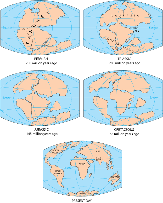
In geologic terms, a plate is a large, rigid slab of solid rock. The word tectonics comes from the Greek root "to build." Putting these two words together, we get the term plate tectonics, which refers to how the Earth's surface is built of plates. The theory of plate tectonics states that the Earth's outermost layer is fragmented into a dozen or more large and small plates that are moving relative to one another as they ride atop hotter, more mobile material. Before the advent of plate tectonics, however, some people already believed that the present-day continents were the fragmented pieces of preexisting larger landmasses ("supercontinents"). The diagrams below show the break-up of the supercontinent Pangaea (meaning "all lands" in Greek), which figured prominently in the theory of continental drift -- the forerunner to the theory of plate tectonics.


According to the continental drift theory, the supercontinent Pangaea began to break up about 225-200 million years ago, eventually fragmenting into the continents as we know them today.

Plate tectonics is a relatively new scientific concept, introduced some 30 years ago, but it has revolutionized our understanding of the dynamic planet upon which we live. The theory has unified the study of the Earth by drawing together many branches of the earth sciences, from paleontology (the study of fossils) to seismology (the study of earthquakes). It has provided explanations to questions that scientists had speculated upon for centuries -- such as why earthquakes and volcanic eruptions occur in very specific areas around the world, and how and why great mountain ranges like the Alps and Himalayas formed.

Why is the Earth so restless? What causes the ground to shake violently, volcanoes to erupt with explosive force, and great mountain ranges to rise to incredible heights?

Scientists, philosophers, and theologians have wrestled with questions such as these for centuries. Until the 1700s, most Europeans thought that a Biblical Flood played a major role in shaping the Earth's surface. This way of thinking was known as "catastrophism," and geology (the study of the Earth) was based on the belief that all earthly changes were sudden and caused by a series of catastrophes. However, by the mid-19th century, catastrophism gave way to "uniformitarianism," a new way of thinking centered around the "Uniformitarian Principle" proposed in 1785 by James Hutton, a Scottish geologist. This principle is commonly stated as follows: The present is the key to the past. Those holding this viewpoint assume that the geologic forces and processes -- gradual as well as catastrophic -- acting on the Earth today are the same as those that have acted in the geologic past.

The belief that continents have not always been fixed in their present positions was suspected long before the 20th century; this notion was first suggested as early as 1596 by the Dutch map maker Abraham Ortelius in his work Thesaurus Geographicus. Ortelius suggested that the Americas were "torn away from Europe and Africa . . . by earthquakes and floods" and went on to say: "The vestiges of the rupture reveal themselves, if someone brings forward a map of the world and considers carefully the coasts of the three [continents]." Ortelius' idea surfaced again in the 19th century. However, it was not until 1912 that the idea of moving continents was seriously considered as a full-blown scientific theory -- called Continental Drift -- introduced in two articles published by a 32-year-old German meteorologist named Alfred Lothar Wegener. He contended that, around 200 million years ago, the supercontinent Pangaea began to split apart. Alexander Du Toit, Professor of Geology at Witwatersrand University and one of Wegener's staunchest supporters, proposed that Pangaea first broke into two large continental landmasses, Laurasia in the northern hemisphere and Gondwanaland in the southern hemisphere. Laurasia and Gondwanaland then continued to break apart into the various smaller continents that exist today.

Wegener's theory was based in part on what appeared to him to be the remarkable fit of the South American and African continents, first noted by Abraham Ortelius three centuries earlier. Wegener was also intrigued by the occurrences of unusual geologic structures and of plant and animal fossils found on the matching coastlines of South America and Africa, which are now widely separated by the Atlantic Ocean. He reasoned that it was physically impossible for most of these organisms to have swum or have been transported across the vast oceans. To him, the presence of identical fossil species along the coastal parts of Africa and South America was the most compelling evidence that the two continents were once joined.

In Wegener's mind, the drifting of continents after the break-up of Pangaea explained not only the matching fossil occurrences but also the evidence of dramatic climate changes on some continents. For example, the discovery of fossils of tropical plants (in the form of coal deposits) in Antarctica led to the conclusion that this frozen land previously must have been situated closer to the equator, in a more temperate climate where lush, swampy vegetation could grow. Other mismatches of geology and climate included distinctive fossil ferns (Glossopteris) discovered in now-polar regions, and the occurrence of glacial deposits in present-day arid Africa, such as the Vaal River valley of South Africa.

The theory of continental drift would become the spark that ignited a new way of viewing the Earth. But at the time Wegener introduced his theory, the scientific community firmly believed the continents and oceans to be permanent features on the Earth's surface. Not surprisingly, his proposal was not well received, even though it seemed to agree with the scientific information available at the time. A fatal weakness in Wegener's theory was that it could not satisfactorily answer the most fundamental question raised by his critics: What kind of forces could be strong enough to move such large masses of solid rock over such great distances? Wegener suggested that the continents simply plowed through the ocean floor, but Harold Jeffreys, a noted English geophysicist, argued correctly that it was physically impossible for a large mass of solid rock to plow through the ocean floor without breaking up.

Undaunted by rejection, Wegener devoted the rest of his life to doggedly pursuing additional evidence to defend his theory. He froze to death in 1930 during an expedition crossing the Greenland ice cap, but the controversy he spawned raged on. However, after his death, new evidence from ocean floor exploration and other studies rekindled interest in Wegener's theory, ultimately leading to the development of the theory of plate tectonics.

Plate tectonics has proven to be as important to the earth sciences as the discovery of the structure of the atom was to physics and chemistry and the theory of evolution was to the life sciences. Even though the theory of plate tectonics is now widely accepted by the scientific community, aspects of the theory are still being debated today. Ironically, one of the chief outstanding questions is the one Wegener failed to resolve: What is the nature of the forces propelling the plates? Scientists also debate how plate tectonics may have operated (if at all) earlier in the Earth's history and whether similar processes operate, or have ever operated, on other planets in our solar system.

Developing the theory

Continental drift was hotly debated off and on for decades following Wegener's death before it was largely dismissed as being eccentric, preposterous, and improbable. However, beginning in the 1950s, a wealth of new evidence emerged to revive the debate about Wegener's provocative ideas and their implications. In particular, four major scientific developments spurred the formulation of the plate-tectonics theory: (1) demonstration of the ruggedness and youth of the ocean floor; (2) confirmation of repeated reversals of the Earth magnetic field in the geologic past; (3) emergence of the seafloor-spreading hypothesis and associated recycling of oceanic crust; and (4) precise documentation that the world's earthquake and volcanic activity is concentrated along oceanic trenches and submarine mountain ranges.

Ocean floor mapping

About two thirds of the Earth's surface lies beneath the oceans. Before the 19th century, the depths of the open ocean were largely a matter of speculation, and most people thought that the ocean floor was relatively flat and featureless. However, as early as the 16th century, a few intrepid navigators, by taking soundings with hand lines, found that the open ocean can differ considerably in depth, showing that the ocean floor was not as flat as generally believed. Oceanic exploration during the next centuries dramatically improved our knowledge of the ocean floor. We now know that most of the geologic processes occurring on land are linked, directly or indirectly, to the dynamics of the ocean floor.

"Modern" measurements of ocean depths greatly increased in the 19th century, when deep-sea line soundings (bathymetric surveys) were routinely made in the Atlantic and Caribbean. In 1855, a bathymetric chart published by U.S. Navy Lieutenant Matthew Maury revealed the first evidence of underwater mountains in the central Atlantic (which he called "Middle Ground"). This was later confirmed by survey ships laying the trans-Atlantic telegraph cable. Our picture of the ocean floor greatly sharpened after World War I (1914-18), when echo-sounding devices -- primitive sonar systems -- began to measure ocean depth by recording the time it took for a sound signal (commonly an electrically generated "ping") from the ship to bounce off the ocean floor and return. Time graphs of the returned signals revealed that the ocean floor was much more rugged than previously thought. Such echo-sounding measurements clearly demonstrated the continuity and roughness of the submarine mountain chain in the central Atlantic (later called the Mid-Atlantic Ridge) suggested by the earlier bathymetric measurements.


In 1947, seismologists on the U.S. research ship Atlantis found that the sediment layer on the floor of the Atlantic was much thinner than originally thought. Scientists had previously believed that the oceans have existed for at least 4 billion years, so therefore the sediment layer should have been very thick. Why then was there so little accumulation of sedimentary rock and debris on the ocean floor? The answer to this question, which came after further exploration, would prove to be vital to advancing the concept of plate tectonics.

In the 1950s, oceanic exploration greatly expanded. Data gathered by oceanographic surveys conducted by many nations led to the discovery that a great mountain range on the ocean floor virtually encircled the Earth. Called the global mid-ocean ridge, this immense submarine mountain chain -- more than 50,000 kilometers (km) long and, in places, more than 800 km across -- zig-zags between the continents, winding its way around the globe like the seam on a baseball. Rising an average of about 4,500 meters(m) above the sea floor, the mid-ocean ridge overshadows all the mountains in the United States except for Mount McKinley (Denali) in Alaska (6,194 m). Though hidden beneath the ocean surface, the global mid-ocean ridge system is the most prominent topographic feature on the surface of our planet.

Magnetic striping and polar reversals

Beginning in the 1950s, scientists, using magnetic instruments (magnetometers) adapted from airborne devices developed during World War II to detect submarines, began recognizing odd magnetic variations across the ocean floor. This finding, though unexpected, was not entirely surprising because it was known that basalt -- the iron-rich, volcanic rock making up the ocean floor-- contains a strongly magnetic mineral (magnetite) and can locally distort compass readings. This distortion was recognized by Icelandic mariners as early as the late 18th century. More important, because the presence of magnetite gives the basalt measurable magnetic properties, these newly discovered magnetic variations provided another means to study the deep ocean floor.

A theoretical model of the formation of magnetic striping. New oceanic crust forming continuously at the crest of the mid-ocean ridge cools and becomes increasingly older as it moves away from the ridge crest with seafloor spreading (see text): a. the spreading ridge about 5 million years ago; b. about 2 to 3 million years ago; and c. present-day. 
Early in the 20th century, paleomagnetists (those who study the Earth's ancient magnetic field) -- such as Bernard Brunhes in France (in 1906) and Motonari Matuyama in Japan (in the 1920s) -- recognized that rocks generally belong to two groups according to their magnetic properties. One group has so-called normal polarity, characterized by the magnetic minerals in the rock having the same polarity as that of the Earth's present magnetic field. This would result in the north end of the rock's "compass needle" pointing toward magnetic north. The other group, however, has reversed polarity, indicated by a polarity alignment opposite to that of the Earth's present magnetic field. In this case, the north end of the rock's compass needle would point south. How could this be? This answer lies in the magnetite in volcanic rock. Grains of magnetite -- behaving like little magnets -- can align themselves with the orientation of the Earth's magnetic field. When magma (molten rock containing minerals and gases) cools to form solid volcanic rock, the alignment of the magnetite grains is "locked in," recording the Earth's magnetic orientation or polarity (normal or reversed) at the time of cooling.

As more and more of the seafloor was mapped during the 1950s, the magnetic variations turned out not to be random or isolated occurrences, but instead revealed recognizable patterns. When these magnetic patterns were mapped over a wide region, the ocean floor showed a zebra-like pattern. Alternating stripes of magnetically different rock were laid out in rows on either side of the mid-ocean ridge: one stripe with normal polarity and the adjoining stripe with reversed polarity. The overall pattern, defined by these alternating bands of normally and reversely polarized rock, became known as magnetic striping.

Seafloor spreading and recycling of oceanic crust


The discovery of magnetic striping naturally prompted more questions: How does the magnetic striping pattern form? And why are the stripes symmetrical around the crests of the mid-ocean ridges? These questions could not be answered without also knowing the significance of these ridges. In 1961, scientists began to theorize that mid-ocean ridges mark structurally weak zones where the ocean floor was being ripped in two lengthwise along the ridge crest. New magma from deep within the Earth rises easily through these weak zones and eventually erupts along the crest of the ridges to create new oceanic crust. This process, later called seafloor spreading, operating over many millions of years has built the 50,000 km-long system of mid-ocean ridges. This hypothesis was supported by several lines of evidence: (1) at or near the crest of the ridge, the rocks are very young, and they become progressively older away from the ridge crest; (2) the youngest rocks at the ridge crest always have present-day (normal) polarity; and (3) stripes of rock parallel to the ridge crest alternated in magnetic polarity (normal-reversed-normal, etc.), suggesting that the Earth's magnetic field has flip-flopped many times. By explaining both the zebralike magnetic striping and the construction of the mid-ocean ridge system, the seafloor spreading hypothesis quickly gained converts and represented another major advance in the development of the plate-tectonics theory. Furthermore, the oceanic crust now came to be appreciated as a natural "tape recording" of the history of the reversals in the Earth's magnetic field.

Additional evidence of seafloor spreading came from an unexpected source: petroleum exploration. In the years following World War II, continental oil reserves were being depleted rapidly and the search for offshore oil was on. To conduct offshore exploration, oil companies built ships equipped with a special drilling rig and the capacity to carry many kilometers of drill pipe. This basic idea later was adapted in constructing a research vessel, named the Glomar Challenger, designed specifically for marine geology studies, including the collection of drill-core samples from the deep ocean floor. In 1968, the vessel embarked on a year-long scientific expedition, criss-crossing the Mid-Atlantic Ridge between South America and Africa and drilling core samples at specific locations. When the ages of the samples were determined by paleontologic and isotopic dating studies, they provided the clinching evidence that proved the seafloor spreading hypothesis.

A profound consequence of seafloor spreading is that new crust was, and is now, being continually created along the oceanic ridges. This idea found great favor with some scientists who claimed that the shifting of the continents can be simply explained by a large increase in size of the Earth since its formation. However, this so-called "expanding Earth" hypothesis was unsatisfactory because its supporters could offer no convincing geologic mechanism to produce such a huge, sudden expansion. Most geologists believe that the Earth has changed little, if at all, in size since its formation 4.6 billion years ago, raising a key question: how can new crust be continuously added along the oceanic ridges without increasing the size of the Earth?

This question particularly intrigued Harry H. Hess, a Princeton University geologist and a Naval Reserve Rear Admiral, and Robert S. Dietz, a scientist with the U.S. Coast and Geodetic Survey who first coined the term seafloor spreading. Dietz and Hess were among the small handful who really understood the broad implications of sea floor spreading. If the Earth's crust was expanding along the oceanic ridges, Hess reasoned, it must be shrinking elsewhere. He suggested that new oceanic crust continuously spread away from the ridges in a conveyor belt-like motion. Many millions of years later, the oceanic crust eventually descends into the oceanic trenches -- very deep, narrow canyons along the rim of the Pacific Ocean basin. According to Hess, the Atlantic Ocean was expanding while the Pacific Ocean was shrinking. As old oceanic crust was consumed in the trenches, new magma rose and erupted along the spreading ridges to form new crust. In effect, the ocean basins were perpetually being "recycled," with the creation of new crust and the destruction of old oceanic lithosphere occurring simultaneously. Thus, Hess' ideas neatly explained why the Earth does not get bigger with sea floor spreading, why there is so little sediment accumulation on the ocean floor, and why oceanic rocks are much younger than continental rocks.

Concentration of earthquakes

During the 20th century, improvements in seismic instrumentation and greater use of earthquake-recording instruments (seismographs) worldwide enabled scientists to learn that earthquakes tend to be concentrated in certain areas, most notably along the oceanic trenches and spreading ridges. By the late 1920s, seismologists were beginning to identify several prominent earthquake zones parallel to the trenches that typically were inclined 40-60° from the horizontal and extended several hundred kilometers into the Earth. These zones later became known as Wadati-Benioff zones, or simply Benioff zones, in honor of the seismologists who first recognized them, Kiyoo Wadati of Japan and Hugo Benioff of the United States. The study of global seismicity greatly advanced in the 1960s with the establishment of the Worldwide Standardized Seismograph Network (WWSSN) to monitor the compliance of the 1963 treaty banning above-ground testing of nuclear weapons. The much-improved data from the WWSSN instruments allowed seismologists to map precisely the zones of earthquake concentration worldwide.
Understanding Plate motion 

Scientists now have a fairly good understanding of how the plates move and how such movements relate to earthquake activity. Most movement occurs along narrow zones between plates where the results of plate-tectonic forces are most evident.

 There are four types of plate boundaries:
  • Divergent boundaries -- where new crust is generated as the plates pull away from each other.
  • Convergent boundaries -- where crust is destroyed as one plate dives under another.
  • Transform boundaries -- where crust is neither produced nor destroyed as the plates slide horizontally past each other.
  • Plate boundary zones -- broad belts in which boundaries are not well defined and the effects of plate interaction are unclear.
Divergent boundaries

Divergent boundaries occur along spreading centers where plates are moving apart and new crust is created by magma pushing up from the mantle. Picture two giant conveyor belts, facing each other but slowly moving in opposite directions as they transport newly formed oceanic crust away from the ridge crest.

Perhaps the best known of the divergent boundaries is the Mid-Atlantic Ridge. This submerged mountain range, which extends from the Arctic Ocean to beyond the southern tip of Africa, is but one segment of the global mid-ocean ridge system that encircles the Earth. The rate of spreading along the Mid-Atlantic Ridge averages about 2.5 centimeters per year (cm/yr), or 25 km in a million years. This rate may seem slow by human standards, but because this process has been going on for millions of years, it has resulted in plate movement of thousands of kilometers. Seafloor spreading over the past 100 to 200 million years has caused the Atlantic Ocean to grow from a tiny inlet of water between the continents of Europe, Africa, and the Americas into the vast ocean that exists today.

The volcanic country of Iceland, which straddles the Mid-Atlantic Ridge, offers scientists a natural laboratory for studying on land the processes also occurring along the submerged parts of a spreading ridge. Iceland is splitting along the spreading center between the North American and Eurasian Plates, as North America moves westward relative to Eurasia.


The consequences of plate movement are easy to see around Krafla Volcano, in the northeastern part of Iceland. Here, existing ground cracks have widened and new ones appear every few months. From 1975 to 1984, numerous episodes of rifting (surface cracking) took place along the Krafla fissure zone. Some of these rifting events were accompanied by volcanic activity; the ground would gradually rise 1-2 m before abruptly dropping, signaling an impending eruption. Between 1975 and 1984, the displacements caused by rifting totaled about 7 m.

In East Africa, spreading processes have already torn Saudi Arabia away from the rest of the African continent, forming the Red Sea. The actively splitting African Plate and the Arabian Plate meet in what geologists call a triple junction, where the Red Sea meets the Gulf of Aden. A new spreading center may be developing under Africa along the East African Rift Zone. When the continental crust stretches beyond its limits, tension cracks begin to appear on the Earth's surface. Magma rises and squeezes through the widening cracks, sometimes to erupt and form volcanoes. The rising magma, whether or not it erupts, puts more pressure on the crust to produce additional fractures and, ultimately, the rift zone.

East Africa may be the site of the Earth's next major ocean. Plate interactions in the region provide scientists an opportunity to study first hand how the Atlantic may have begun to form about 200 million years ago. Geologists believe that, if spreading continues, the three plates that meet at the edge of the present-day African continent will separate completely, allowing the Indian Ocean to flood the area and making the easternmost corner of Africa (the Horn of Africa) a large island.

Convergent boundaries

The size of the Earth has not changed significantly during the past 600 million years, and very likely not since shortly after its formation 4.6 billion years ago. The Earth's unchanging size implies that the crust must be destroyed at about the same rate as it is being created, as Harry Hess surmised. Such destruction (recycling) of crust takes place along convergent boundaries where plates are moving toward each other, and sometimes one plate sinks (is subducted) under another. The location where sinking of a plate occurs is called a subduction zone.

The type of convergence -- called by some a very slow "collision" -- that takes place between plates depends on the kind of lithosphere involved. Convergence can occur between an oceanic and a largely continental plate, or between two largely oceanic plates, or between two largely continental plates.
Oceanic-continental convergence

If by magic we could pull a plug and drain the Pacific Ocean, we would see a most amazing sight -- a number of long narrow, curving trenches thousands of kilometers long and 8 to 10 km deep cutting into the ocean floor. Trenches are the deepest parts of the ocean floor and are created by subduction.


Off the coast of South America along the Peru-Chile trench, the oceanic Nazca Plate is pushing into and being subducted under the continental part of the South American Plate. In turn, the overriding South American Plate is being lifted up, creating the towering Andes mountains, the backbone of the continent. Strong, destructive earthquakes and the rapid uplift of mountain ranges are common in this region. Even though the Nazca Plate as a whole is sinking smoothly and continuously into the trench, the deepest part of the subducting plate breaks into smaller pieces that become locked in place for long periods of time before suddenly moving to generate large earthquakes. Such earthquakes are often accompanied by uplift of the land by as much as a few meters.

On 9 June 1994, a magnitude-8.3 earthquake struck about 320 km northeast of La Paz, Bolivia, at a depth of 636 km. This earthquake, within the subduction zone between the Nazca Plate and the South American Plate, was one of deepest and largest subduction earthquakes recorded in South America. Fortunately, even though this powerful earthquake was felt as far away as Minnesota and Toronto, Canada, it caused no major damage because of its great depth.


Oceanic-continental convergence also sustains many of the Earth's active volcanoes, such as those in the Andes and the Cascade Range in the Pacific Northwest. The eruptive activity is clearly associated with subduction, but scientists vigorously debate the possible sources of magma: Is magma generated by the partial melting of the subducted oceanic slab, or the overlying continental lithosphere, or both?

Oceanic-oceanic convergence


As with oceanic-continental convergence, when two oceanic plates converge, one is usually subducted under the other, and in the process a trench is formed. The Marianas Trench (paralleling the Mariana Islands), for example, marks where the fast-moving Pacific Plate converges against the slower moving Philippine Plate. The Challenger Deep, at the southern end of the Marianas Trench, plunges deeper into the Earth's interior (nearly 11,000 m) than Mount Everest, the world's tallest mountain, rises above sea level (about 8,854 m).

Subduction processes in oceanic-oceanic plate convergence also result in the formation of volcanoes. Over millions of years, the erupted lava and volcanic debris pile up on the ocean floor until a submarine volcano rises above sea level to form an island volcano. Such volcanoes are typically strung out in chains called island arcs. As the name implies, volcanic island arcs, which closely parallel the trenches, are generally curved. The trenches are the key to understanding how island arcs such as the Marianas and the Aleutian Islands have formed and why they experience numerous strong earthquakes. Magmas that form island arcs are produced by the partial melting of the descending plate and/or the overlying oceanic lithosphere. The descending plate also provides a source of stress as the two plates interact, leading to frequent moderate to strong earthquakes.

Continental-continental convergence


The Himalayan mountain range dramatically demonstrates one of the most visible and spectacular consequences of plate tectonics. When two continents meet head-on, neither is subducted because the continental rocks are relatively light and, like two colliding icebergs, resist downward motion. Instead, the crust tends to buckle and be pushed upward or sideways. The collision of India into Asia 50 million years ago caused the Indian and Eurasian Plates to crumple up along the collision zone. After the collision, the slow continuous convergence of these two plates over millions of years pushed up the Himalayas and the Tibetan Plateau to their present heights. Most of this growth occurred during the past 10 million years. The Himalayas, towering as high as 8,854 m above sea level, form the highest continental mountains in the world. Moreover, the neighboring Tibetan Plateau, at an average elevation of about 4,600 m, is higher than all the peaks in the Alps except for Mont Blanc and Monte Rosa, and is well above the summits of most mountains in the United States.


Above: The collision between the Indian and Eurasian plates has pushed up the Himalayas and the Tibetan Plateau. Below: Cartoon cross sections showing the meeting of these two plates before and after their collision. The reference points (small squares) show the amount of uplift of an imaginary point in the Earth's crust during this mountain-building process.


Transform boundaries

The zone between two plates sliding horizontally past one another is called a transform-fault boundary, or simply a transform boundary. The concept of transform faults originated with Canadian geophysicist J. Tuzo Wilson, who proposed that these large faults or fracture zones connect two spreading centers (divergent plate boundaries) or, less commonly, trenches (convergent plate boundaries). Most transform faults are found on the ocean floor. They commonly offset the active spreading ridges, producing zig-zag plate margins, and are generally defined by shallow earthquakes. However, a few occur on land, for example the San Andreas fault zone in California. This transform fault connects the East Pacific Rise, a divergent boundary to the south, with the South Gorda -- Juan de Fuca -- Explorer Ridge, another divergent boundary to the north.


The San Andreas fault zone, which is about 1,300 km long and in places tens of kilometers wide, slices through two thirds of the length of California. Along it, the Pacific Plate has been grinding horizontally past the North American Plate for 10 million years, at an average rate of about 5 cm/yr. Land on the west side of the fault zone (on the Pacific Plate) is moving in a northwesterly direction relative to the land on the east side of the fault zone (on the North American Plate).

Oceanic fracture zones are ocean-floor valleys that horizontally offset spreading ridges; some of these zones are hundreds to thousands of kilometers long and as much as 8 km deep. Examples of these large scars include the Clarion, Molokai, and Pioneer fracture zones in the Northeast Pacific off the coast of California and Mexico. These zones are presently inactive, but the offsets of the patterns of magnetic striping provide evidence of their previous transform-fault activity.

Plate-boundary zones

Not all plate boundaries are as simple as the main types discussed above. In some regions, the boundaries are not well defined because the plate-movement deformation occurring there extends over a broad belt (called a plate-boundary zone). One of these zones marks the Mediterranean-Alpine region between the Eurasian and African Plates, within which several smaller fragments of plates (microplates) have been recognized. Because plate-boundary zones involve at least two large plates and one or more microplates caught up between them, they tend to have complicated geological structures and earthquake patterns.
Rates of motion

We can measure how fast tectonic plates are moving today, but how do scientists know what the rates of plate movement have been over geologic time? The oceans hold one of the key pieces to the puzzle. Because the ocean-floor magnetic striping records the flip-flops in the Earth's magnetic field, scientists, knowing the approximate duration of the reversal, can calculate the average rate of plate movement during a given time span. These average rates of plate separations can range widely. The Arctic Ridge has the slowest rate (less than 2.5 cm/yr), and the East Pacific Rise near Easter Island, in the South Pacific about 3,400 km west of Chile, has the fastest rate (more than 15 cm/yr).

Evidence of past rates of plate movement also can be obtained from geologic mapping studies. If a rock formation of known age -- with distinctive composition, structure, or fossils -- mapped on one side of a plate boundary can be matched with the same formation on the other side of the boundary, then measuring the distance that the formation has been offset can give an estimate of the average rate of plate motion. This simple but effective technique has been used to determine the rates of plate motion at divergent boundaries, for example the Mid-Atlantic Ridge, and transform boundaries, such as the San Andreas Fault.

Current plate movement can be tracked directly by means of ground-based or space-based geodetic measurements; geodesy is the science of the size and shape of the Earth. Ground-based measurements are taken with conventional but very precise ground-surveying techniques, using laser-electronic instruments. However, because plate motions are global in scale, they are best measured by satellite-based methods. The late 1970s witnessed the rapid growth of space geodesy, a term applied to space-based techniques for taking precise, repeated measurements of carefully chosen points on the Earth's surface separated by hundreds to thousands of kilometers. The three most commonly used space-geodetic techniques -- very long baseline interferometry (VLBI), satellite laser ranging (SLR), and the Global Positioning System (GPS) -- are based on technologies developed for military and aerospace research, notably radio astronomy and satellite tracking.

More Info : Click Here 

Brief Explanation : 

The geological process by which the Earth came to have its present interior structure is called differentiation

Within about 1 billion years of its formation the Earth was melted by heat arising from a combination of sources:

Gravitational energy left from the formation of the planet,


Meteor bombardment


Decay of radioactive material trapped in the body of the Earth.


While the Earth was molten, gravity acted to concentrate more dense material near the center and less dense material nearer the surface. When the Earth solidified again (except for the liquid outer core) it was left with a layered structure with more dense material like iron and nickel near the center and less dense rocks nearer the surface. As the outer layers cooled and solidified, large cracks developed because of thermal stress, leaving the lithosphere broken up into large blocks or plates.It is now agreed that the crustal plates of the Earth are in horizontal motion. This is called continental drift colloquially, and plate tectonics in technically more precise language.The crust is thin, varying from a few tens of kilometers thick beneath the continents to to less than 10 km thick beneath the many of the oceans. The crust and upper mantle together constitute the lithosphere, which is typically 50-100 km thick and is broken into large plates (not illustrated). These plates sit on the aesthenosphere.

The aesthenosphere is kept plastic (deformable) largely through heat generated by radioactive decay. The material that is decaying is primarily radioactive isotopes of light elements like aluminum and magnesium. This heat source is small on an absolute scale (the corresponding heat flow at the surface out of the Earth is only about 1/6000 of the Solar energy falling on the surface). Nevertheless, because of the insulating properties of the Earth's rocks this is sufficient to keep the aesthenosphere plastic in consistency.

The original conjectures concerning plate tectonics were based on circumstantial evidence like the shapes of continents being such that they would fit well if pushed together. Today, we have a much broader set of evidence in favor of the hypothesis.

Indications of Tectonic Activity

Among the classes of evidence for continental drift and the underlying plate tectonics we may list
  • The shapes of many continents are such that they look like they are separated pieces of a jig-saw puzzle. For example, look in the adjacent map at the shape of the east coast of North and South Americal relative to the shape of the west coast of Africa and Europe.
  • Many fossil comparisons along the edges of continents that look like they fit together suggest species similarities that would only make sense if the two continents were joined at some point in the past.
  • There is a large amount of seismic, volcanic, and geothermal activity along the conjectured plate boundaries. This is shown clearly below in the figure labeled "Crustal plate boundaries" where the epicenters of earthquakes above Richter magnitude 5.0 are plotted for a 10-year period. The concentration is striking, and indeed this plot serves to define the plate boundaries extremely well.
  • There are ridges, such as the Mid-Atlantic Ridge (see figures above and below) where plates are separating that are produced by lava welling up from between the plates as they pull apart. Likewise, there are mountain ranges being formed where plates are pushing against each other (e.g., the Himalayas, which are still growing).
Age of the Sea Floor

If the crustal plates are pulling apart at boundaries like the Mid-Atlantic Ridge the sea floor near these ridges should be very young geologically, since it is formed of material upwelling from the interior.

Past and future consequences of plate tectonics for the Earth's surface are enormous.


Some Past and Present Consequences

Plate tectonics has been responsible for many of the features that we find on the surface of the Earth today.
  • A few examples include The Appalachian Mountains were formed from wrinkling of the Earth's surface produced by the collision of the North American and African plates.
  • The seismic and volcanic activity of the West Coast of the United States (for example, the San Andreas Fault) is produced by the grinding of the Pacific and North American Plates against each other. Indeed, the entire "ring of fire" around the Pacific, corresponding to regions of high volcanic and seismic activity, is caused primarly by the motion of the Pacific Plate.
  • The Dead Sea in Israel is part of a rift system produced by plates that are pulling apart in that region.
  • The Himalayan Mountains were formed (indeed are still growing) as a result of the Indian subplate burrowing under the Eurasian plate and raising its edge.
Some Future Consequences of Plate Tectonics

Plate tectonics is still an active process, and will drastically reshape the face of the Earth over the next 50 million years or so. A few consequences of plate tectonics based on projections of present motion include:
  • Portions of California will separate from the rest of North America.
  • The Italian "boot" will disappear.
  • Australia will become linked to Asia.
  • Africa will separate from the Near East. 
As a consequence of plate tectonics (supplemented by wind and water erosion), we live on the surface of a geologically active planet that has obliterated most of its early geological history.

Source : USGS